
Wageningen University & Research Unmanned Aerial Remote Sensing Facility (UARSF)
To support environmental management there is increasing need for timely, accurate and detailed information on our land. Drones or Unmanned Aerial Vehicles (UAV) are increasingly used to monitor agricultural crop development, habitat quality or urban heat efficiency. An important reason is that UAV technology is maturing quickly while the flexible capabilities of UAV fill a gap between satellite based and ground based geo-sensing systems.
In 2012, different groups within Wageningen University & Research established an Unmanned Airborne Remote Sensing Facility (UARSF). The objective of this facility is threefold:
- To develop innovation in the field of remote sensing science by providing a platform for dedicated and high-quality experiments;
- To support high quality UAS services by providing calibration facilities and disseminating processing procedures to the UAS user community;
- To promote and test the use of UAS in a broad range of application fields like habitat monitoring, precision agriculture and land degradation assessment.
Currently, several groups from Wageningen University and Research take part in the facility: these include the Laboratory of Geo-Information Science and Remote Sensing (GRS) and the chair group Information Technology, Wageningen Food Safety Research, Unifarm and NPEC of Wageningen Plant Research, and the Earth Informatics team of Wageningen Environmental Research.
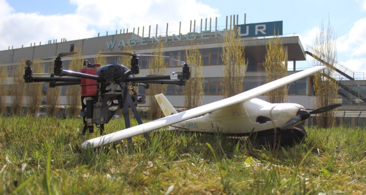
Description of facility
The added value of the Unmanned Aerial Remote Sensing Facility (UARSF) is that compared to for example satellite-based remote sensing, more dedicated science experiments can be prepared. This includes for example higher frequent observations in time (e.g., diurnal observations), observations of an object under different observation angels for characterization of BRDF and flexibility in use of cameras and sensor types. In this way, laboratory type of set-ups can be tested in a field situation and effects of up-scaling can be tested.
Within the facility a range of UAV platforms are available: these include the following rotor-based systems DJI S1000, DJI M100, DJI M210, DJI Phantom, DJI Mavic, while also we have a fixed system available: the Sensefly Ebee. The choice of a specific platform depends on the requirements of the experiment and capabilities of the platform.
Next to UAV platforms, also a large range of camera systems can be used:
- Headwall Nano Hyperspectral camera combined with LiDAR system
- Hyperspectral mapping system (HYMSY)
- Rikola hyperspectral camera
- Wiris thermal camera
- RGB-NIR camera (MUMSY)
- Several RGB camera’s: including DJI Zenmuse X7
- Sequoia multi-spectral camera
- Fluorescence point-spectrometer (FluorSpec)
- Several chemical sensors to measure gas components and atmospheric particles
Finally, we are operating a Laser Scanning system on a UAV: this is the Riegl Ricopter. from this LiDAR system, detailed and precise 3D models of objects can be collected and mapped.
Projects
The following projects are using or have been using the expertise and equipment of the UARSF:
- I-Seeds (H2020; 2021-2024): GRS partner: developing a new generation of self-deployable and biodegradable soft miniaturized robots
- PalmWatch (BELSPO; 2019-2022): GRS partner: Using remote sensing to tackle red palm weevil in palms
- EU project GENTORE (H2020: 2018-2022): WENR: Phenotyping livestock with drones
- KB-NPEC (Kennisbasis 2018-2022). Phenotyping with drones
- Automated Airborne Pest Management (NWO; 2017-2020): GRS partner
- PPS PrecisieTuinbouw ‘Next Generation Phenotyping’ (2017-2020). WENR
- Spectors (Interreg; 2016-2020): GRS en WEnR partner
Relevant PhD and postdoc projects
- Tianyi Jia (2023-2026): UAV remote sensing data fusion with deep learning for early detection of potato diseases.
- Hasib Mustafa (postdoc, 2021-2024): Towards new frontiers for distributed environmental monitoring based on an ecosystem of plant seed-like soft robots (I-Seed).
- Magdalena Smigaj (postdoc, 2021-2023): Multi-modal UAV-based sensing for agricultural monitoring.
- Kaiwen Wang (2021-2025): UAV-based Semantic Localization and Mapping of Woody Crops.
- Zhen Cao (2021-2025): Real-time crop disease detection by using UAVs and AI.
- Yaowu Wang (2021-2025): From Detection to Identification and Phenotyping of Free-range Cattle with Aerial Data from UAVs using Deep Learning technologies.
- Wan Quanxing (2019-2023): Monitoring crop water stress from local to regional scale: supporting farmland water management.
- Norazlida Jamil (2019-2023): Individual Plant-Growth Monitoring Based On UAV Imaging.
- Chenglong Zhang (2018-2022): Spatial and temporal yield estimation and prediction for orchard management using high-resolution UAV-based imagery technology.
- Na Wang (2017-2021): Measuring sun-induced fluorescence using UAVbased remote sensing.
- Gustavo Togeiro de Alckmin (2016-2020): Compare and contrast approaches of measurement of perennial ryegrass for biophysical and biochemical attributes.
- Marston Domingues Franceschini (2014-2020): Multiple sensor data fusion and time-series analysis for near-real time monitoring and detecting changes in biophysical and chemical crop conditions.
Relevant links education
Open source UAV datasets
- Randwijk (NL) Apple Orchard RGB (2023): Data on three-year flowering intensity monitoring in an apple orchard: A collection of RGB images acquired from unmanned aerial vehicles
- Vineyard (ES) RGB Video (2021): UAV acquired RGB videos including mask labels of visible grape bunches.
- Vineyard (ES) Multi-spectral (2021): UAV acquired multispectral images from varying heights and camera angles.
- Kleve (DE): Dataset on UAV High-resolution Images from Grassland with Broad-leaved Dock (Rumex Obtusifolius).
- Wageningen (NL): point-based SIF measurements from Fluorspec instrument under UAV.
- Kleve (DE): UAV-based Hyperspectral images of Haus Riswick grassland experiment with N fertilization and plant growth monitoring.
- Wageningen (NL): UAV-based Multispectral & Thermal dataset for exploring the diurnal variability, radiometric & geometric accuracy for precision agriculture.
- Speulderbos (NL): Terrestrial (TLS) and Unmanned Aerial Vehicle Laser Scanning (UAV-LS) 2017.
Publications
2023
-
A review of three-dimensional computer vision used in precision livestock farming for cattle growth management
Computers and Electronics in Agriculture (2023), Volume: 206 - ISSN 0168-1699 -
Decoupling physiological and non-physiological responses of sugar beet to water stress from sun-induced chlorophyll fluorescence
Remote Sensing of Environment (2023), Volume: 286 - ISSN 0034-4257 -
Detection of Artificial Seed-like Objects from UAV Imagery
Remote Sensing (2023), Volume: 15, Issue: 6 - ISSN 2072-4292 -
Estimating body dimensions and weight of cattle on pasture with 3D models from UAV imagery
Smart Agricultural Technology (2023), Volume: 4 - ISSN 2772-3755 -
Estimation of spinach (Spinacia oleracea) seed yield with 2D UAV data and deep learning
Smart Agricultural Technology (2023), Volume: 3 - ISSN 2772-3755 -
Feasibility assessment of tree-level flower intensity quantification from UAV RGB imagery : A triennial study in an apple orchard
ISPRS Journal of Photogrammetry and Remote Sensing (2023), Volume: 197 - ISSN 0924-2716 - p. 256-273. -
-
Mapping the spatial variability of Botrytis bunch rot risk in vineyards using UAV multispectral imagery
European Journal of Agronomy (2023), Volume: 142 - ISSN 1161-0301 -
Monitoring Individual Tree Phenology in a Multi-Species Forest Using High Resolution UAV Images
Remote Sensing (2023), Volume: 15, Issue: 14 - ISSN 2072-4292 -
Object detection and tracking on UAV RGB videos for early extraction of grape phenotypic traits
Computers and Electronics in Agriculture (2023), Volume: 211 - ISSN 0168-1699 - p. 108051-108051.
2022
-
Automatic flower cluster estimation in apple orchards using aerial and ground based point clouds
Biosystems Engineering (2022), Volume: 221 - ISSN 1537-5110 - p. 164-180. -
Comparison of a UAV- and an airborne-based system to acquire far-red sun-induced chlorophyll fluorescence measurements over structurally different crops
Agricultural and Forest Meteorology (2022), Volume: 323 - ISSN 0168-1923 -
Detection, identification and posture recognition of cattle with satellites, aerial photography and UAVs using deep learning techniques
International Journal of Remote Sensing (2022), Volume: 43, Issue: 7 - ISSN 0143-1161 - p. 2377-2392. -
Evaluating Data Inter-Operability of Multiple UAV–LiDAR Systems for Measuring the 3D Structure of Savanna Woodland
Remote Sensing (2022), Volume: 14, Issue: 23 - ISSN 2072-4292 -
Evaluation of Individual Plant Growth Estimation in an Intercropping Field with UAV Imagery
Agriculture (Switzerland) (2022), Volume: 12, Issue: 1 - ISSN 2077-0472 -
Mapping of Rumex obtusifolius in nature conservation areas using very high resolution UAV imagery and deep learning
International Journal of applied Earth Observation and Geoinformation (2022), Volume: 112 - ISSN 1569-8432 -
Non-destructive estimation of individual tree biomass : Allometric models, terrestrial and UAV laser scanning
Remote Sensing of Environment (2022), Volume: 280 - ISSN 0034-4257 -
Peering through the thicket : Effects of UAV LiDAR scanner settings and flight planning on canopy volume discovery
International Journal of applied Earth Observation and Geoinformation (2022), Volume: 114 - ISSN 1569-8432 -
Perennial ryegrass biomass retrieval through multispectral UAV data
Computers and Electronics in Agriculture (2022), Volume: 193 - ISSN 0168-1699 -
Potential of UAV-based sun-induced chlorophyll fluorescence to detect water stress in sugar beet
Agricultural and Forest Meteorology (2022), Volume: 323 - ISSN 0168-1923
2021
-
A shortest path based tree isolation method for UAV LiDAR data
-
Characterising Termite Mounds in a Tropical Savanna with UAV Laser Scanning
Remote Sensing (2021), Volume: 13, Issue: 3 - ISSN 2072-4292 -
Diurnal variation of sun-induced chlorophyll fluorescence of agricultural crops observed from a point-based spectrometer on a UAV
International Journal of applied Earth Observation and Geoinformation (2021), Volume: 96 - ISSN 1569-8432 -
Effectiveness of soil erosion barriers to reduce sediment connectivity at small basin scale in a fire-affected forest
Journal of Environmental Management (2021), Volume: 278 - ISSN 0301-4797 -
Inferring ethylene temporal and spatial distribution in an apple orchard (Malus domestica Borkh) : a pilot study for optimal sampling with a gas sensor
Horticulture Environment and Biotechnology (2021), Volume: 62, Issue: 2 - ISSN 2211-3452 - p. 213-224. -
Orchard management with small unmanned aerial vehicles : a survey of sensing and analysis approaches
Precision Agriculture (2021), Volume: 22, Issue: 6 - ISSN 1385-2256 - p. 2007-2052. -
Quantifying tropical forest stand structure through terrestrial and UAV laser scanning fusion
-
Pilot innovatieve inwinning zeegras Oosterschelde
-
Towards new frontiers for distributed environmental monitoring based on an ecosystem of plant seed-like soft robots
In: GoodIT 2021 - Proceedings of the 2021 Conference on Information Technology for Social Good - Association for Computing Machinery, Inc - ISBN: 9781450384780 - p. 221-224. -
Uav-based land cover classification for hoverfly (Diptera : Syrphidae) habitat condition assessment: A case study on mt. stara planina (Serbia)
Remote Sensing (2021), Volume: 13, Issue: 16 - ISSN 2072-4292
2020
-
A Cloud-Based Environment for Generating Yield Estimation Maps From Apple Orchards Using UAV Imagery and a Deep Learning Technique
Frontiers in Plant Science (2020), Volume: 11 - ISSN 1664-462X -
An open simulation strategy for rapid control design in aerial and maritime drone teams : A comprehensive tutorial
Drones (2020), Volume: 4, Issue: 3 - ISSN 2504-446X -
Automated crop plant counting from very high-resolution aerial imagery
Precision Agriculture (2020), Volume: 21 - ISSN 1385-2256 - p. 1366-1384. -
Biomass and crop height estimation of different crops using UAV-based LiDAR
Remote Sensing (2020), Volume: 12, Issue: 1 - ISSN 2072-4292 -
Calibration of Electrochemical Sensors for Nitrogen Dioxide Gas Detection Using Unmanned Aerial Vehicles
Sensors (2020), Volume: 20, Issue: 24 - ISSN 1424-8220 -
Comparing methods to estimate perennial ryegrass biomass: canopy height and spectral vegetation indices
Precision Agriculture (2021), Volume: 22 - ISSN 1385-2256 - p. 205-225. -
Deep learning for automated detection of Drosophila suzukii : potential for UAV-based monitoring
Pest Management Science (2020), Volume: 76, Issue: 9 - ISSN 1526-498X - p. 2994-3002. -
Experimental flight patterns evaluation for a UAV-based air pollutant sensor
Micromachines (2020), Volume: 11, Issue: 8 - ISSN 2072-666X -
Identifying and Quantifying the Abundance of Economically Important Palms in Tropical Moist Forest Using UAV Imagery
Remote Sensing (2020), Volume: 12, Issue: 1 - ISSN 2072-4292 -
Impact of flight altitude and cover orientation on Digital Surface Model (DSM) accuracy for flood damage assessment in Murcia (Spain) using a fixed-wing UAV
Earth Science Informatics (2020), Volume: 13 - ISSN 1865-0473 - p. 391-404.
2019
-
Comparing Filtering Techniques for Removing Vegetation from UAV-Based Photogrammetric Point Clouds
Drones (2019), Volume: 3, Issue: 3 - ISSN 2504-446X -
Non-destructive tree volume estimation through quantitative structure modelling: Comparing UAV laser scanning with terrestrial LIDAR
Remote Sensing of Environment (2019), Volume: 233 - ISSN 0034-4257 -
Using Unmanned Aerial Systems (UAS) and Object-Based Image Analysis (OBIA) for Measuring Plant-Soil Feedback Effects on Crop Productivity
Drones (2019), Volume: 3, Issue: 3 - ISSN 2504-446X -
Fast Classification of Large Germinated Fields Via High-Resolution UAV Imagery
IEEE Robotics and Automation Letters (2019), Volume: 4, Issue: 4 - ISSN 2377-3766 - p. 3216-3223. -
Feasibility of Unmanned Aerial Vehicle Optical Imagery for Early Detection and Severity Assessment of Late Blight in Potato
Remote Sensing (2019), Volume: 11, Issue: 3 - ISSN 2072-4292 -
A Comprehensive Study of the Potential Application of Flying Ethylene-Sensitive Sensors for Ripeness Detection in Apple Orchards
Sensors (Basel, Switzerland) (2019), Volume: 19, Issue: 2 - ISSN 1424-8220 -
Editorial of special issue “drones for biodiversity conservation and ecological monitoring”
Drones (2019), Volume: 3, Issue: 2 - ISSN 2504-446X - p. 1-4. -
Automatic apple tree blossom estimation from uav rgb imagery
In: ISPRS Geospatial Week 2019, 10–14 June 2019, Enschede, The Netherlands - ISPRS - p. 631-635.
2018
-
Geometric Tree Modelling with UAV-based Lidar
-
Opportunities of UAV based Sensing for Vegetation Land Product Validation
-
Assessment of Potato Disease Infestation Using Combined Sources Of High-Resolution UAV Imagery
-
Inter-row Weed Detection of Sugar Beet Fields Using Aerial Imagery
-
UAV-imaging to model growth response of marram grass to sand burial : Implications for coastal dune development
Aeolian Research (2018), Volume: 31 - ISSN 1875-9637 - p. 50-61. -
Improved estimation of leaf area index and leaf chlorophyll content of a potato crop using multi-angle spectral data – potential of unmanned aerial vehicle imagery
International Journal of applied Earth Observation and Geoinformation (2018), Volume: 66 - ISSN 1569-8432 - p. 14-26. -
Automated Airborne Pest Monitoring of Drosophila suzukii in Crops and Natural Habitats
-
Comparing terrestrial laser scanning and unmanned aerial vehicle structure from motion to assess top of canopy structure in tropical forests
Interface Focus (2018), Volume: 8, Issue: 2 - ISSN 2042-8898 -
Mapping the Leaf Economic Spectrum across West African Tropical Forests Using UAV-Acquired Hyperspectral Imagery
Remote Sensing (2018), Volume: 10, Issue: 10 - ISSN 2072-4292 -
The Electronic Smell of the Orchard Fruit
2017
-
Capturing forest structure and change – 5 years of laser scanning and future perspectives using UAV based LiDAR
In: SilviLaser 2017 Program - Blacksburg: Virginia Tech - p. 61-62. -
Capturing forest structure using UAV based LiDAR
-
Predicting fire behaviour (in-)directly via plant traits and Remote Sensing
-
Comparing RIEGL RiCOPTER UAV LiDAR Derived Canopy Height and DBH with Terrestrial LiDAR
Sensors (2017), Volume: 17, Issue: 10 - ISSN 1424-8220 -
Intercomparison of unmanned aerial vehicle and ground-based narrow band spectrometers applied to crop trait monitoring in organic potato production
Sensors (2017), Volume: 17, Issue: 6 - ISSN 1424-8220 -
Assessing changes in potato canopy caused by late blight in organic production systems through UAV-based pushbroom imaging spectrometer
International Archives of the Photogrammetry, Remote Sensing and Spatial Information Science (2017), Volume: 42, Issue: 2W6 - ISSN 1682-1750 - p. 109-112. -
Unmanned Aerial Remote Sensing Facility of Wageningen UR: Overview of Activities
Geophysical Research Abstracts (2017), Volume: 19 - ISSN 1029-7006 -
Remote sensing of plant trait responses to field-based plant-soil feedback using UAV-based optical sensors
Biogeosciences (2017), Volume: 14, Issue: 3 - ISSN 1726-4170 - p. 733-749. -
Exploring the contributions of vegetation and dune size to early dune development using unmanned aerial vehicle (UAV) imaging
Biogeosciences (2017), Volume: 14, Issue: 23 - ISSN 1726-4170 - p. 5533-5549. -
Detecting animals in African Savanna with UAVs and the crowds
Remote Sensing of Environment (2017), Volume: 200 - ISSN 0034-4257 - p. 341-351.
2016
-
Field phenotyping of maize growth parameters using UAV acquired high-resolution hyperspectral images
-
Remote sensing of plant trait responses to field-based plant-soil feedback using UAV-based optical sensors
Biogeosciences (2017), Volume: 14, Issue: 3 - ISSN 1726-4170 - p. 733-749. -
Hyperspectral Reflectance Anisotropy Measurements Using a Pushbroom Spectrometer on an Unmanned Aerial Vehicle—Results for Barley, Winter Wheat, and Potato
Remote Sensing (2016), Volume: 8, Issue: 11 - ISSN 2072-4292