
Wageningen World
A day counting fish on the marker mudflats
Seven years ago, a group of islands called the Marker Mudflats was created by dredging in the Markermeer lake. The idea was to restore the ecology of what had by all accounts become a dead tank of water full of swirling silt. The fish stocks are one indicator of whether this restoration effort is having any success. A report of 24 hours counting fish.
This story was previously published in Wageningen World 2 | 2023, magazine of Wageningen University & Research
Text and photography: Marieke Enter
Clad in a green rubber wading suit, fish researcher Joey Volwater of Wageningen Marine Research strides into the water in the small marina on the Marker Mudflats. After about five metres, he comes to a stop, grins and declares the water temperature to be ‘warm as piss’. A few months ago, he and University of Amsterdam Master’s student Elizabeth Manoloulis stood on this same spot shivering from the cold. That was in early April, the time of year when the spawning season starts for many freshwater fish species.
Since then, they have visited the Marker Mudflats every three to four weeks to document the numbers and sizes of the fish species they find. Today is their last visit for the year. It is the end of September, but the weather feels summery with a temperature of around 21 degrees, abundant sun and a light breeze. However, the fish will soon be looking for deeper waters to prepare for their winter resting period. One last 24-hour session and that will be the end of the 2023 fish monitoring season.
Not reclaimed
The Marker Mudflats project consists of seven small islands in the Markermeer lake, created by depositing more than 35 million cubic metres of sand, mud and clay from the lake bed. The Netherlands originally planned to drain the lake, as it did previously for the reclaimed land of Noordoostpolder, Oostelijk Flevoland and Zuidelijk Flevoland. A dyke was built for this purpose – the Markerwaarddijk, also known as the Houtribdijk. It was completed in 1976, but the land was never reclaimed and the Dutch government officially scrapped the plan in 2002. Meanwhile, Markermeer gradually changed into what was frankly a dead tank of water full of swirling silt. That was largely due to the lack of natural shoreline zones, gullies and shallows.
Young pike and rudd are a sign that the reedbeds are becoming established
The Marker Mudflats, an initiative of the nature preservation society Natuurmonumenten, were constructed in 2016 to bring about ecological restoration. The islands were designed with a lot of shallow zones, and the gullies between the islands were raised to give water depths of one to two metres. A great deal of variation was incorporated in the island shorelines, ranging from sand devoid of vegetation to fields of marsh ragwort and reedbeds. The idea was that lee zones behind the islands would give the swirling silt the chance to sink to the lake bed, while the islands themselves could function as valuable nurseries and foraging areas for birds and fish. Given the encouraging ecological results for the first five islands – Wageningen research showed that biodiversity had increased at various levels in the food chain – Natuurmonumenten and the Directorate-General for Public Works and Water Management decided in early 2021 to build two more islands. Their construction was completed this year, giving the Marker Mudflats a total surface area (above and below water) of 1300 hectares.
Multi-day research
The Marker Mudflats are uninhabited but you can visit them. Or at least the main island, and mainly during the day. You can only stay overnight in one of the four off-grid island chalets, and there are a limited number of berths in the marina. But researchers and students get special treatment: to allow research over several days, Natuurmonumenten erected an off-grid group hut with ten bunk beds.
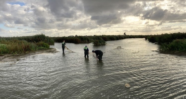
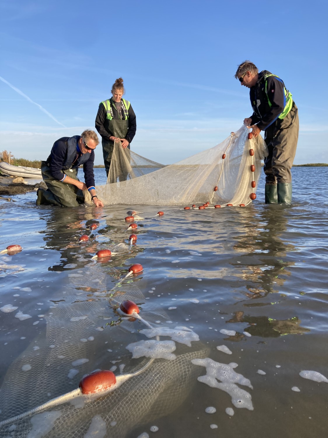
This particular 24-hour session involves three WUR researchers and their two student assistants – one from the University of Amsterdam and one from Utrecht University. The group accommodation looks out over the first shoreline fish count site for today, the marina. It has depths of four to five metres, relatively deep for the Marker Mudflats and with more shelter than other areas too. Volwater is standing up to his waist in the water to grab the net that researcher Olvin van Keeken is feeding out of his rubber dinghy. It is what is known as a hatchery seine net, an elongated net that stands upright in the water with the aid of floats at the top and weights at the bottom.
Van Keeken carefully arranges the net in a semi-circle in the water, after which he and Volwater gently pull the ends towards one another. Once the circle is closed, the fish swimming inside it have only one place to go: the bulge in the centre. When the researchers haul in the net, it catches all the fish like a kind of sack.
Silvery mass
[kop] Silvery mass The catch is measured with great precision. The researchers carefully lay the net in a large plastic container with plenty of water in it. The contents look like a writhing silvery mass at first but the fish soon calm down. In a practised routine, Volwater moistens his hands – this prevents harm to the fish – and picks out the largest fish, which measures about 30 centimetres. He explains that the larger fish are more sensitive to stress and so he measures them first. This one is a bream. That’s a surprise, says project manager Joep de Leeuw. ‘We don’t often see ones this size here at this time of year.’
Learning lessons from research
Other research projects besides the fish monitoring focus on the Marker Wadden. For example, Jeroen Veraart of Wageningen Environmental Research (WEnR) is studying the governance of the Marker Wadden for the ministry of Agriculture, Nature and Food Quality. The aim of his research is to learn lessons for the governance of other landscape projects around Building with Nature, including the Programmatic Approach to the Main Water Systems, aimed at improving water quality. Another example is the WEnR study on the elements of the Marker Wadden design that might be useful in the Purifying Landscape project. This is a collaboration with drinking water company PWN, which draws most of its water from the IJsselmeer. And Wageningen Marine Research and WEnR collaborated on a recently published analysis of the ‘benefits for nature’ mindset in relation to the main water systems, looking at options such as the development of new habitats.
The shoreline counts are always conducted in the same spots, selected to represent a range of shoreline types varying in sedimentation, vegetation and water depths, and consequently also in currents and water temperature. Thanks to that variation, they form habitats for different species of flora and fauna. That includes the fish: marshy banks with dense growth attract different species of fish compared with the beach-like sandy, open shoreline. To measure the ecological effect of the Marker Mudflats, the researchers need to figure out what species are found there and in what stages of growth.
Triggering bite reflex
The researchers manage to identify all the fish at an impressive rate – including the little ones a centimetre or two long. ‘See how that mouth is pointing upwards. That tells you it’s a bleak, a surface predator, and not a roach,’ explains De Leeuw. He identifies another tiny fish by triggering a bite reflex with his fingertip. Snap! So it’s clearly a predatory fish, a pike-perch to be precise, a species that is fished commercially in the lake.
The researchers use an instrument they made themselves to measure the fish. It’s a tray with a ruler screwed onto it. The tray simplifies the careful measuring procedure: place the fish with its nose against the crossbar, hold it firmly so it doesn’t wriggle away, and read out the size by its tail so Manoloulis can note down the result. A deft hand movement by the researcher sends the fish sliding back into the water through the gap in the tray’s rim.

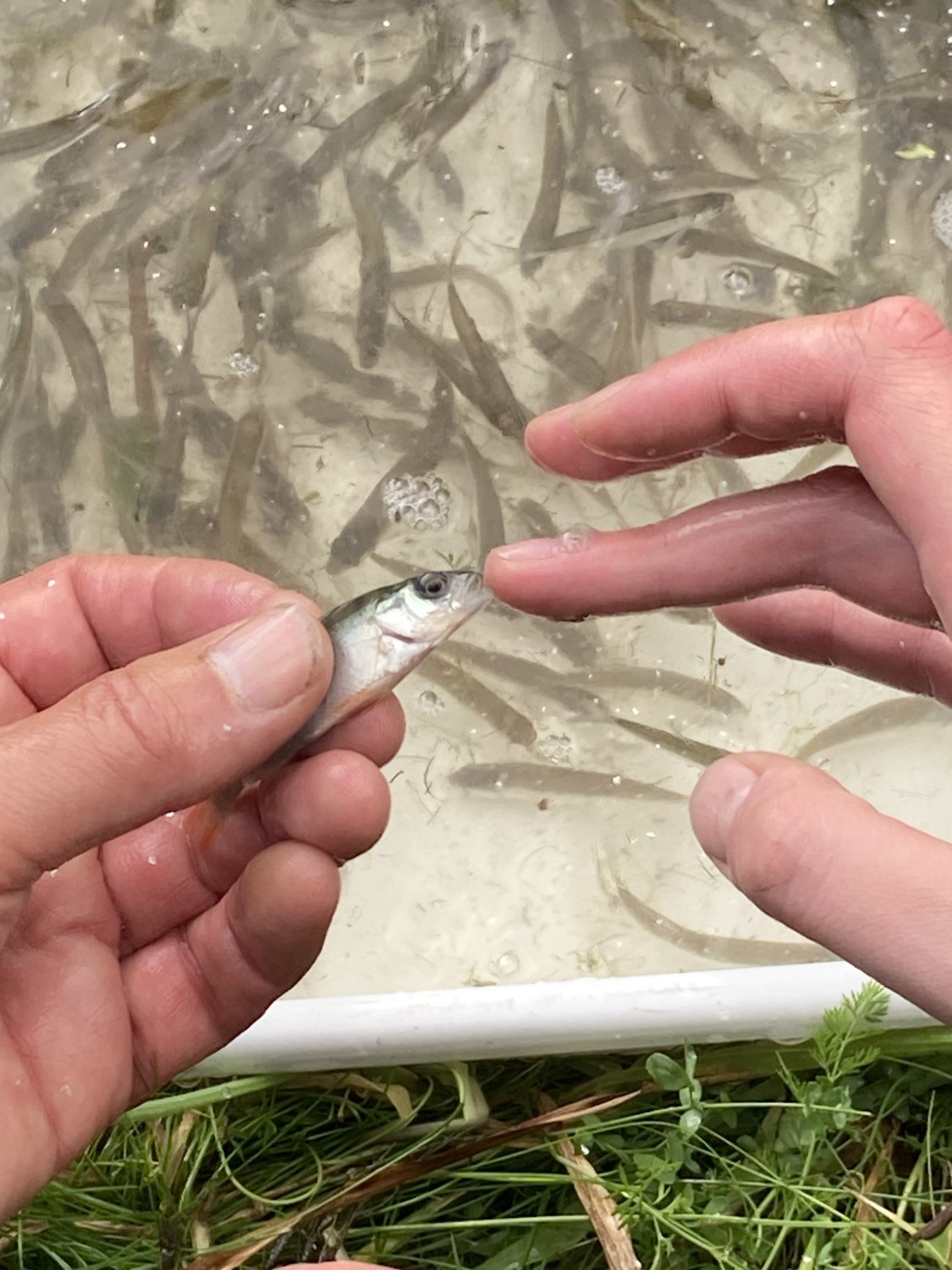
By the time the container is empty, the A4 sheet on Manoloulis’ clipboard is full of tally marks recording the fish species and their lengths in centimetres: ‘Pike-perch, nine. Blackmouth gudgeon, four. Perch, five. Ruffle, four. Carp, six. Roach, four. Roach, four. Another roach, four.’ They are all offspring from this breeding season that are now big enough for a connoisseur to identify them by sight. The tiny larvae caught earlier in the season had to be identified in the lab, under the microscope.
Slurping sounds
As early evening approaches, it is time to set the traps for the counts in the little waterways that connect the open water to the creeks in the ‘interior’ of the mudflats. That too covers a variety of habitat types, with one trap for the fish swimming out to the lake and one for the fish headed inwards. The traps are next to one another, with ‘wings’ that prevent the fish from swimming around them.
As she sets the traps, Utrecht Biology student Emma Eggert discovers first-hand that the Marker Mudflats really do largely consist of a thick layer of mud. As she lowers herself into the water from a platform, she becomes completely stuck. Loud slurping noises from the ooze are evidence of the struggle she has to break loose. ‘Wiggle your feet, don’t stand still and try to keep your weight on your toes,’ advises the old hand Volwater.
The next morning, the dawn skies and water of the Marker Mudflats are a bright orange. The researchers doing the shoreline counts take the dinghy while the trap team set off by bike or in the electric golf cart they have on loan from Natuurmonumenten – indispensable for transporting the large quantities of fish materials. The place is now full of birds. The researchers constantly point them out: spoonbills, snipe, teal, dabchicks, blue-headed wagtails. De Leeuw in particular turns out to be a walking bird encyclopaedia, with a sharp eye and ear. ‘A spotted redshank, can you hear it?’ And when a sound like a screeching piglet is heard from the reeds, ‘No doubt about that one, it’s a water rail!’
Sturdy eels
The first site where the traps are installed is called ‘Flamingo’: the researchers call each site after a particular bird they spotted there. In addition to the same species that were found in the seine net the previous day, these traps also contain two spotted American crayfish and some sturdy-looking eels. The crayfish are parked temporarily in a transparent tray so that student Eggert can examine them in more detail; she is researching invasive exotic species.
For the eels, the researchers produce a new homemade measuring instrument, the ‘eel flume’, which makes measuring such a slippery customer a whole lot easier. Pour in some water, manoeuvre the flume under the eel, push the eel in, wait until it unwinds itself and stretches out — then quickly read off the length.
At the ‘Bearded Tit’ trap site, the eponymous birds make abundantly clear why the researchers chose this name. They flutter up, over and in between the reeds in their dozens or even hundreds. Their calls are unmistakable. ‘Like knocking two pebbles together’ is how Volwater describes it. In the traps, the researchers find not only a Chinese mitten crab – an exotic species – but also some interesting new species: thin-lip mullet, ide, common rudd and a young pike.

The presence of the last two species in particular, as typical reedbed inhabitants, says something about the establishment of the reedbeds, explains Volwater. Reed growth on the Marker Mudflats is not yet optimal, partly because of damage by geese and the ‘unnatural’ water level management, with higher levels in summer and lower levels in winter. The young pike and rudd are therefore a sign that the reedbeds are becoming established after all. That is good news because reedbeds are important as spawning grounds for adult fish and nurseries for larvae and young fish.
Four newcomers
Once all the traps have been emptied and the fish that were caught have been recorded, the 2023 Marker Mudflats monitoring season has come to an end. The actual data analysis still has to start, but the researchers make a quick provisional assessment. They have found 21 different species of fish, including four newcomers: the pike, Prussian carp, common rudd and tench, all four typical reedbed residents. That is a hopeful sign the new island group is starting to move on from the ecological ‘pioneer’ stage and live up to its promise of becoming a significant nursery for Dutch freshwater fish – and consequently a source of food for migratory and other birds.
Three-spined sticklebacks make ideal food for spoonbills
The researchers have identified two clear peaks during the season on the Marker Mudflats regarding the supply of food for birds. The first is in early April, when threespined sticklebacks swim up the creeks and gullies of the Marker Mudflats in huge numbers to spawn. With a length of about six centimetres, they are ideal food for birds such as spoonbills. The second peak starts during June, when the fish born that year are just big enough to be caught by the monitoring nets, and can no longer swim through the holes in the net. Young perch, roach bream and pike-perch in particular form the supply of food in this second peak, which lasts until the end of September.
One of the key insights from the long-term monitoring of the fish around the Marker Mudflats is that the restoration of shallow freshwater shore zones with a gradual transition from land to water can soon result in new, productive habitats. It also turns out that the various shoreline types differ in how they develop. Unlike the exposed sandy shoreline, vegetation quickly takes hold on the more sheltered banks of nutrient-rich clay and mud sediment, which soon leads to habitats for young fish.
Thanks to such insights, the research on the Marker Mudflats is providing important pointers for design and construction in possible similar restoration projects in the future. This knowledge is not only relevant to the Netherlands. As project manager De Leeuw notes, ‘Given that humans are changing and damaging ecosystems around the world, there is a lot of demand for examples of how to stop and reverse the negative effects.’
Long-term ecological fish research
Wageningen Marine Research conducts fish research on the Marker Mudflat islands for various projects. For the Knowledge and Innovation programme Marker Wadden II, commissioned by the Directorate-General for Public Works and Water Management, Deltares and Natuurmonumenten, WUR is monitoring the extent to which the Marker Mudflats are achieving the ecological recovery that they were created for.
Fish stocks around the islands’ shoreline are also investigated for the annual shoreline counts in the IJsselmeer and Markeermeer waters. That is for the Ministry of Agriculture, Nature and Food Quality, which uses the data in part as the basis for catch recommendations for commercial freshwater fisheries. This research has been ongoing since 2011; in 2023, nearly 100 kilometres of new shoreline around the Marker Mudflats and Trintelzand were added to the monitoring sites on the recommendation of Wageningen Marine Research. These new sites are more varied than the other shorelines – mainly dykes made of basalt rocks – and therefore have potential as a habitat for different kinds of fish species.
The third research project concerns fish as a source of food for spoonbills; this is for the Nieuw Land National Park, consisting of Oostvaardersplassen, Lepelaarplassen, Trintelzand, Markermeer and Marker Mudflats.