
News of the Laboratory of Geo-information Science and Remote Sensing
-

LiDAR-UAV quantifying tropical forest structure in Australia
- In 2018, a team of researchers from Ghent University, Wageningen University, the Commonwealth Scientific and Industrial Research Organisation (CSIRO),... -

Good start of year: two new UAV papers
- In January 2022, two new research papers from two PhDs of the Unmanned Aerial Remote Sensing Facility have been published. The paper prepared by... -

Large Area Aboveground Biomass and Carbon Stock Mapping in Woodlands in Mozambique with L-Band Radar: Improving Accuracy by Accounting for Soil Moisture Effects Using the Water Cloud Model
- An article of Yaqing Gou, Casey M. Ryan and Johannes Reiche: Large Area Aboveground Biomass and Carbon Stock Mapping in Woodlands in Mozambique with... -

Indigenous lands in the Amazon under increasing threat
- The impact of deforestation and wildfires on indigenous peoples living in the Amazon rain forest, have recently been quantified in a study of Judith... -

Factors Influencing Temperature Measurements from Miniaturized Thermal Infrared (TIR) Cameras: A Laboratory-Based Approach
- From the 1970s on, satellite-based thermal infrared (TIR) remote sensing has been applied widely to regional-scale investigations. In this century,... -
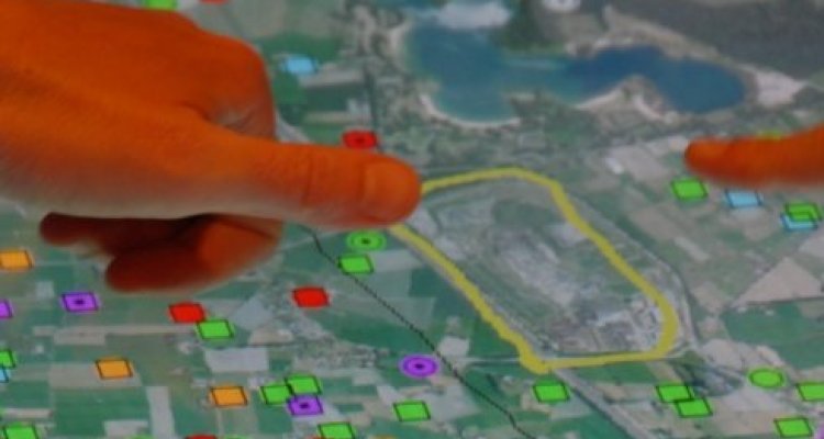
Detect deforestation faster with new method: 'Within days'
- At the 2021 Climate Conference COP 26 in Glasgow, British Prime Minister Johnson calls it a "milestone": the promise to end deforestation by... -

Land & Carbon Lab
- The World Resources Institute (WRI) has just unveiled the Land & Carbon Lab, a new initiative harnessing the data revolution to monitor the pulse... -

RADD forest disturbance alerts now available for South America
- We expanded the RADD forest disturbance alerts to South America (13 countries) and now have pan-tropical coverage. -
Improving Forest Baseline Maps in Tropical Wetlands Using GEDI-Based Forest Height Information and Sentinel-1
- An article of Kamiel Verhelst, Yaqing Gou, Martin Herold, Johannes Reiche: Improving Forest Baseline Maps in Tropical Wetlands Using GEDI-Based Forest... -

Understanding forest change in Tanzania opens door for improved management
- The work of Daniela Requena Suarez, Danaë Rozendaal, Veronique De Sy, David Gibbs, Nancy Harris, Joseph Sexton, Min Feng, Saurabh Channan,...