
Models of Geo-Information Science and Remote Sensing: HILDA
+++NEWS+++: New HILDA data sets (version 2.0) are available for download
+++NEWS+++: HILDA in the news: Washington Post, Der Spiegel, NRC, Gazetta Wyborcza, Vize Magazine Netherlands, Ouest France, Sueddeutsche Zeitung.
+++NEWS+++: HILDA goes public. Take a tour, check out our data and visit our new interactive story map available as app.
The HILDA data set is part of a PhD project with the title: A data-driven reconstruction of historic land cover/use change of Europe for the period 1900 to 2010.
Content of this webpage:
- Get a short interactive introduction about HILDA with our story map
- The concept of HILDA
- Features of the HILDA data sets

The concept of HILDA:
The HIstoric Land Dynamics Assessment (HILDA) is a new concept for the reconstruction of historic land cover/use and its changes.
HILDA combines multiple harmonized and consistent data streams of historic land cover information in one approach, like remote sensing products, national inventories, aerial photographs, land cover statistics, old encyclopaedias and historic land cover maps.
By using the potential of the harmonized data streams our model benefits from an improved quality of land change trends over the whole period as we have more measured data sources available to rely on. Spatial data streams also provide detailed information about where land changes happened, which improves the allocation of land cover change information in our model. Finally, spatial data streams also provide information where land cover conversions types occurred (e.g. from forest to cropland).
Our model takes more accurate quantification methods of land changes into account (gross changes instead of net changes), offers a full land change matrix and provides maps for every decade.
The modelling results of HILDA can be used by many different user groups, for example in biogeochemical-, ecological- and environmental assessments, such as climate change research. Our available data sets are free for download, as many additional supporting information.
Features of the HILDA data sets:
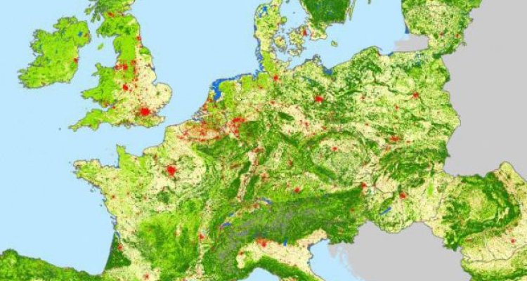
- Spatial resolution: 1km by 1km
- Spatial extent: EU-27 plus Switzerland
- Temporal resolution: decadal (10 years) for the period 1900-2010
- Thematic resolution: Six Classes, namely:
- Settlements (incl. green urban areas), whit three density layers: low, medium and high,
- Cropland (incl. orchards and agro-forestry),
- Forest (incl. transitional shrub and woodland, tree nurseries, reforested areas for forestry purposes),
- Grassland (incl. natural grassland, wetlands, pasture and Mediterranean shrub vegetation),
- Other Land (incl. glaciers, sparsely vegetated areas, beaches, bare soil)
- Water (incl. water bodies, sea, streams).
- Available data format for download: ArcGIS map package, ESRI grid, TIFF or ASCII
- Land change accounting method: Gross land changes or net land changes